
Browse Items (12 total)
Sort by:
Photo of Men Working Along Front St., Decatur, IL.

Photograph of men working on railroad tracks along Front St., Decatur, IL.
Photo of Men Working Along Front St., Decatur, IL.

Photograph of men working on railroad tracks along Front St., Decatur, IL.
Wabash Railway Station Map: Lands, Tracks and Structures - Monroe St. to Wabash Yards (6/30/194?)
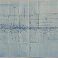
This station map shows the Wabash Railway tracks from Monroe St. to the Wabash yards.
Illinois Central Railroad Station Plat Map - Decatur St. to Cerro Gordo St. (9/11/195?, revised 11/30/1955)

This map shows the Illinois Central Railroad tracks from Decatur St. to Cerro Gordo St. The map shows the industries, additions, and streets between Decatur St. and Cerro Gordo St.
Wabash Railway Station Map: Lands, Tracks and Structures - N. Monroe St to Wabash Yards (6/30/1919)
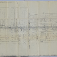
This station map shows the Wabash Railway's lands, tracks, and structures between N. Monroe St. and the Wabash yards.
Illinois Central Railroad Station Map - Northern Cross (9/1939)

This map shows the Illinois Central Railroad crossing the Wabash Railroad at the Northern Cross in September 1939. It also shows the Wabash RR yards, businesses, and streets around the Northern Cross.
Illinois Central Railroad Station Plat Map - Decatur St. to Cerro Gordo St. (9/11/1951)

This is a station plat map for Illinois Central Railroad showing the tracks from Decatur St. to Cerro Gordo St. It also includes the streets and businesses between those two streets, and the Wabash RR tracks.
Illinois Central Railroad Station Plat Map - Eldorado St. to Hickory St. (8/12/1953)

This is a station plat map for Illinois Central Railroad showing the tracks from Eldorado St. to Hickory St. The map includes the Wabash RR and Pennsylvania RR tracks, streets, and additions.
Illinois Central Railroad Station Plat Map - Eldorado St. to Hickory St. (12/26/1951)

This is a station plat map for Illinois Central Railroad showing the tracks from Eldorado St. to Hickory St. The map includes the Wabash RR and Pennsylvania RR tracks, streets, and additions.
Photo of first house on the "levee" known as the Wittke House.

Photograph of "old frame house stood at 517 N. Maryland street at Front street. It was first used as a Boarding House and was said to be the first house on the 'levee'. It was last used as a place of business by Fred Wittke. Photo ran Herald Sept. 5,…